
Isabelle Charleux – Representing the Sino-Mongol Frontier in the Late Qing Period: Mongol and Qing Chinese perspectives.
(See English below)
Im Rahmen der internationalen Konferenz „Reframing Tibetan and Mongol Mapmaking Practices“ hält Isabelle Charleux (CNRS, Paris), am Donnerstag, 26. November 2026 ab 18 Uhr im Fontane Saal der Staatsbibliothek zu Berlin (Unter den Linden 8) ihre öffentliche Keynote zu dem Thema: Representing the Sino-Mongol Frontier in the Late Qing Period: Mongol and Qing Chinese perspectives.
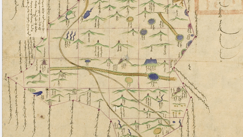
The production of geographical information about Inner Asia constituted a fundamental component of the process of incorporating such regions into the Qing Empire. In the first decade of the 20th century, as part of the reforms known as the New Policies—an ultimate effort to modernize the imperial state—the Qing government commissioned Mongol princes to produce new maps designed to make frontier territories knowable and, consequently, their natural resources more readily exploitable. This talk examines the case of a Mongol banner located in the Josoto League of eastern Inner Mongolia, a frontier zone historically contested between Chinese imperial authority and Inner Asian pastoral polities. Despite the presence of the Willow Palisade, the colonization of the banner by Chinese migrants accelerated in the context of the New Policies. The banner was gradually integrated into the Chinese provincial and prefectural administrative system, while maintaining separate administrative structures for Mongols and Chinese. This talk compares different visual representations of the same banner, each employing distinct “cartographic languages.” A Mongol map, likely produced in the Mongol banner compared and later annotated in Chinese (with misunderstandings of orientation), and its more abstract copy probably made in the capital—are with Qing/Chinese maps of the same territory. Although commissioned by the central Qing government, these different maps reflect divergent political interests. None of them captures the banner’s dual identity; rather, each tends to render the presence of the “other” invisible. The paper argues that the Mongol map depicts an idealized or earlier situation, constructing an “auspicious visual narrative” that does not align with contemporary political and ethnic realities, whereas the Qing/Chinese interpretations seek to “domesticate” the territory by inscribing it within a Chinese administrative and conceptual framework.
Die Vortragssprache ist Englisch. Bei Fragen kontaktieren Sie uns unter: ostasienabt@sbb.spk-berlin.de.
Die internationale Konferenz „Reframing Tibetan and Mongol Mapmaking Practices (pre-20th century)“ bringt vom 26. November bis 28. November 2026 Forschende aus Geschichte, Area Studies, Kunstgeschichte, Anthropologie, Geographie, Museumskunde und Linguistik in Berlin zusammen um mongolische und tibetische Kartierungspraktiken vor dem 20. Jahrhundert vergleichend zu untersuchen. Organisiert wird sie gemeinsam von Prof. Diana Lange (Humboldt-Universität zu Berlin), Prof. Anne-Sophie Pratte (Georgetown University in Qatar) und Antje Ziemer (Staatsbibliothek zu Berlin), in Partnerschaft mit der Staatsbibliothek zu Berlin, insbesondere der Orientabteilung und der Kartenabteilung. Die Vorträge am Donnerstag und Freitag können nach Anmeldung besucht werden. Das Vortragsprogramm wird rechtzeitig online veröffentlicht. Zur Teilnahme als Zuhörer und weiteren Fragen zur Konferenz kontaktieren Sie bitte: tibetmongolmaps@gmail.com
—
As part of the international conference ‘Reframing Tibetan and Mongol Mapmaking Practices’, Isabelle Charleux (CNRS, Paris) will deliver her public keynote address on Thursday, 26 November 2026, from 6.00 pm in the Fontane Saal at the Berlin State Library (Unter den Linden 8) on the topic: Representing the Sino-Mongol Frontier in the Late Qing Period: Mongol and Qing Chinese perspectives.
The production of geographical information about Inner Asia constituted a fundamental component of the process of incorporating such regions into the Qing Empire. In the first decade of the 20th century, as part of the reforms known as the New Policies—an ultimate effort to modernize the imperial state—the Qing government commissioned Mongol princes to produce new maps designed to make frontier territories knowable and, consequently, their natural resources more readily exploitable. This talk examines the case of a Mongol banner located in the Josoto League of eastern Inner Mongolia, a frontier zone historically contested between Chinese imperial authority and Inner Asian pastoral polities. Despite the presence of the Willow Palisade, the colonization of the banner by Chinese migrants accelerated in the context of the New Policies. The banner was gradually integrated into the Chinese provincial and prefectural administrative system, while maintaining separate administrative structures for Mongols and Chinese. This talk compares different visual representations of the same banner, each employing distinct “cartographic languages.” A Mongol map, likely produced in the Mongol banner compared and later annotated in Chinese (with misunderstandings of orientation), and its more abstract copy probably made in the capital—are with Qing/Chinese maps of the same territory. Although commissioned by the central Qing government, these different maps reflect divergent political interests. None of them captures the banner’s dual identity; rather, each tends to render the presence of the “other” invisible. The paper argues that the Mongol map depicts an idealized or earlier situation, constructing an “auspicious visual narrative” that does not align with contemporary political and ethnic realities, whereas the Qing/Chinese interpretations seek to “domesticate” the territory by inscribing it within a Chinese administrative and conceptual framework.
The lecture will be held in English. If you have any questions, please contact us: ostasienabt@sbb.spk-berlin.de.
The international conference “Reframing Tibetan and Mongol Mapmaking Practices (pre-20th century)” will bring together researchers from the fields of history, area studies, art history, anthropology, geography, museology and linguistics in Berlin from 26 November to 28 November 2026 to conduct a comparative study of Mongolian and Tibetan cartographic practices prior to the 20th century. It is jointly organised by Prof. Diana Lange (Humboldt University of Berlin), Prof. Anne-Sophie Pratte (Georgetown University in Qatar) and Antje Ziemer (Berlin State Library), in partnership with the Berlin State Library, in particular its Orient Department and Map Department. The lectures on Thursday and Friday are open to the public upon registration. The programme of lectures will be published online in due course. To attend as a member of the audience or for further enquiries regarding the conference, please contact: tibetmongolmaps@gmail.com.
 rechts: C.H. Beck Verlag; links: KR.FILM GbR