 Public Domain
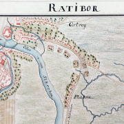
On an attempt to reconstruct the image of Silesian towns in the 18th century on the basis of historical cartography: Kriegskarte von Schlesien
Gastbeitrag von Prof. Monika Ewa Adamska I’ve been conducting research in the Silesia area, which has been a historically contested region in Central Europe for many years, focusing on the transformations of its historical rural and urban structures, colonisation processes, the issues of post-war rebuilding and contemporary revitalisation processes. For a brief introduction to the […]